Details – Hurricane Irene
Storm Path:
Storm Facts:
| Storm Life | October 13 – 19, 1999 |
| Landfall | Key West, FL Cape Sable, FL |
| T.S. FCMP Deployment | October 16 – 17, 1999 |
| Estimated Damage | $800 Million |
| Casualties | 8 |
| Links | NOAA – NHC, AOML |
Synopsis of FCMP Deployment
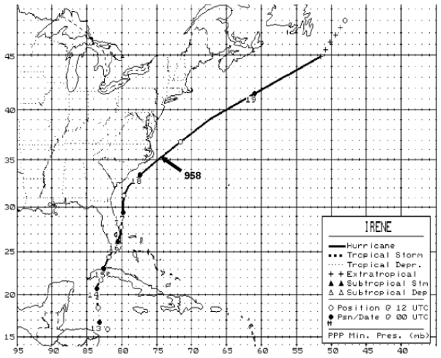
At 1200 UTC on October 13, 1999, Irene reached tropical storm status in the northwestern Caribbean Sea and kept a general northward track before slowing down and curving to the north-northeast southwest of the Isle of Youth, Cuba. The center of the storm crossed the Havana and Ciudad Havana provinces on the 14th. Irene reached hurricane status over the Florida Straits before its center moved over Key West and made landfall near Cape Sable, Florida as a tropical storm. The cyclone trekked across southeast Florida, eventually reemerging back over water in northern Palm Beach County near Jupiter at approximately 0000 UTC on the 16th. UF and CU teams arrived in Melbourne Beach prior to the storm’s arrival on the evening of the 15th, where colleagues from Florida Institute of Technology and local authorities assisted in the location of deployment sites. With their assistance, teams were able to begin acquiring data by 1100 UTC. During the night, Irene regained hurricane strength and began a northward track paralleling the Florida east coast heading for the Carolinas. An upper-level trough, sweeping eastward across the eastern United States, sped its progress. On the morning of the 16th, teams collected the towers and caravanned up the I-95 corridor to intercept the storm. Within a few hours, the convoy was traveling parallel to Irene, where buffeting winds and unavailability of fuel (gasoline pumps require power to operate) significantly impeded the team’s progress. At 0100 UTC on the 17th, twenty-five hours after the departure from Melbourne Beach, teams arrived in Wilmington, NC, where two towers were deployed. Residential and shoreline exposure were chosen—the shoreline site would be later reused by Tower T1 in Hurricane Isabel. The FCMP only succeeded in capturing the outer bands of Irene in North Carolina because the cyclone veered away from the mainland and brushed the Outer Banks before moving out to sea.
Participating Team Members
Kurt Gurley, Ph.D.
Krista Hayes
Forrest Masters
Tim Reinhold, Ph.D.
Scott Robinette
Dennis —
Assisting:
Jean-Paul Pinelli, Florida Institute of Technology
Spencer Rogers, North Carolina Sea Grant