The 2003 season introduces two important new additions to the portable tower hurricane data collection system. Prototype testing was concluded during Hurricane Isabel.
Real Time Data Acquisition
Recognizing that real time knowledge of surface level wind speeds during hurricane landfall would aid:
- meteorological institutions forecasting the hurricane’s path and local news affiliates providing weather updates to the public
- federal, state and local agencies conducting emergency management operations
- utility companies assessing potential damage and estimating a time of safe entry to begin restoration of power, water, telephones, etc
- the FCMP itself, which needs to respond quickly to any problem that might occur during data acquisition
The FCMP program has enhanced its existing hardware and software on its mobile tower system to disseminate real time data over the internet. Each of the four 10-meter towers is newly equipped with laptops that orchestrate collection, post-processing and internet connectivity from National Instrument’s LabVIEW platform. Cellular technology allows the computer to transmit data from the tower to remote network servers every 15 minutes over Verizon’s Express Network service (with average upload speeds of 60-70 kb/s). The new software, dubbed Tower XP, was developed at the University of Florida.
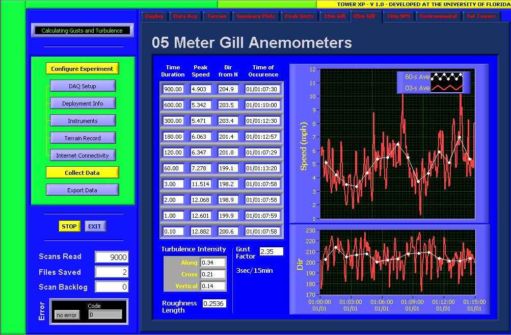
For redundancy and effective division of tasks, the FCMP team decided to use the original tower computer software (sampling at 100 Hz) in conjunction with the new hardware/software (sampling at 10 Hz). Since additional storage space was needed, new computer enclosures had to be constructed to house the laptops, cellular modem and CDMA antenna (as seen below).
Welding 16-Gauge Steel 
New Enclosure (top)
Satellite Towers
Each of the four portable towers are typically deployed several miles apart, in order to capture wind behavior in a variety of local terrains and proximity to the coast. Each of the four towers have been outfitted with additional smaller (5-meter) towers to be placed in close proximity to the main towers, wired into the same data collection system. The objective of adding satellite towers to each main tower is to provide a much closer spacing of fixed points. This allows the analysis of the lateral size of gusts as they pass the array of main and satellite towers. The lateral size of gusts is an important parameter when determining how strong winds cause damage to houses.
Development of the 5-m satellite tower system to aid in correlation, length scale and turbulence studies completed in July 2003. Lightweight (<80 lbs) and highly portable, the aluminum towers may be erected up to 120 ft from the main tower. The picture below was taken during the recent deployment for Tropical Storm Henri.
The satellite towers are separated from the main tower by 50 ft (background) and 100 ft (foreground). This asymmetric configuration allows the FCMP teams to look at correlations of wind speeds between 50, 100 and 150 ft.
With good soil conditions, a team of three people can assemble one tower in under 30 minutes. The deployment strategy is simple. As usual, the main tower is erected with the tongue of the trailer facing the direction of anticipated maximum winds (into the path of the storm at landfall). Next, the team removes the satellite towers from the main tower (shown attached below) and places them 50 and 100 ft on opposite sides of the main tower.
Stabilizing the tower is the next priority. The satellite towers employ two measures to resist the wind: four shear pins are driven with a sledgehammer to resist sliding (as seen in the left picture) and three guy wires attach the top of the tower to earth screws to provide lateral stability (as seen in the right picture).
Shear Pins 
Earth Screws and Guy Wires
Once the guy wires are attached at the top of the tower, the team augurs the earth screws into the ground and attaches the gill anemometers (bottom left picture). Then, the team raises the tower and attaches the guy wires to the earth screws. The turnbuckles (top right picture) are tightened to remove slack and to level the tower. Finally, safety ribbons (bottom right picture) are tied to the guy wires for visibility, and a shielded cable is connected from the main tower’s computer enclosure to the satellite tower.
Anemometry 
Attaching Ribbons for Visibility