Details – Hurricane Lili
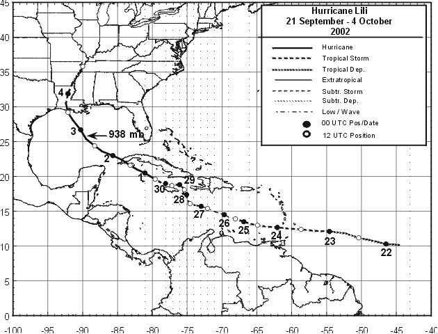
Storm Path:
Storm Facts:
| Storm Life | September 21 – October 4, 2002 |
| Landfall | Intracoastal City, LA – Cat I |
| FCMP Deployment | October 1 – October 5, 2002 |
| Estimated Damage | $430 Million† |
| Casualties | 6 |
| Links | NOAA – NHC, AOML |
Synopsis of FCMP Deployment
As the center of Hurricane Lili trekked past the southwest tip of the Isle of Youth over western mainland Cuba on October 1st, FCMP teams from CU and UF traveled to Mobile, Alabama. On the morning of October 2nd (while the cyclone turned northward through the Gulf of Mexico), FCMP personnel and equipment caravanned to Baton Rouge, Louisiana and set up base camp. In the afternoon, the team split into two deployment groups. The first team traveled west along I-10 inserting towers in Lafeyette (T0) and Baton Rouge (T1). The second team traveled south placing towers in Donaldsonville (T2) and Lydia (T3). With 9 personnel working, the four towers went operational over a 7-hour period (between 2/2303 and 3/0616 UTC).
Between Cuba and Louisiana, Lili intensified to 64.4 m/s (144 mph) early on the 3rd over the north-central Gulf of Mexico and then rapidly weakened during the 13 hours until landfall. Lili made landfall on the Louisiana coast with an estimated 41.2 m/s (92.2 mph) maximum wind speed.
Participating Team Members
Cos Gardener
Glen Haris
Jon Lamb
Mark Leviatan, LSU
Forrest Masters
Matt McCann
Jamie Padgett
Tim Reinhold, Ph.D.
Scott Robinette
Kirby –, LSU
Robin Weaver
†Source: American Insurance Services Group